HISTORIX Vintage 1895 Saint Louis Missouri Map - 18x24 Inch Vintage Map of St Lo
Shipping options
Seller handling time is 2 business days Details
This reflects the seller's handling time and may not include time spent in transit.
If you have questions about shipping, please contact the seller.
FREE via to United States
Return policy
Full refund available for DOAs
Details
- We guarantee our products and offer full refunds or exchange for defective items or items not as-described.
- Buyer must contact us within 30 days after receipt of shipment.
- The item must be received in the same condition as shipped.
- Items must be returned with all original packaging and accessories.
- Items must not be abused, modified or damaged by accident.
- A 20% restocking fee will be charged for returns
- Buyer is responsible for all return shipping and handling fees.
- Restocking and return shipping fees do not apply when item is returned as defective or because incorrect product was delivered.
Payment options
PayPal accepted
PayPal Credit accepted
Venmo accepted
PayPal, MasterCard, Visa, Discover, and American Express accepted
Maestro accepted
Amazon Pay accepted
Nuvei accepted
Item traits
| Category: |
Kitchen Scales
|
| Quantity Available: |
16 in stock
|
| Condition: |
New
|
| ASIN: |
B08M6CQK32
|
| Item Name: |
HISTORIX 1895 St Louis Missouri
|
| manufacturer: |
HISTORIX
|
| Item Type Keyword: |
prints
|
| Product Site Launch Date: |
2020-10-29T15:42:26.933Z
|
| Brand: |
HISTORIX
|
| Unspsc Code: |
52140000
|
| sizes: |
View details
24L" x 18W" (8 in stock)
36L" x 24W" (8 in stock)
|
Listing details
|
Seller policies:
|
View seller policies
|
|
Shipping discount:
|
Seller pays shipping for this item.
|
|
Posted for sale:
|
May 1
|
|
Item number:
|
1743603963
|
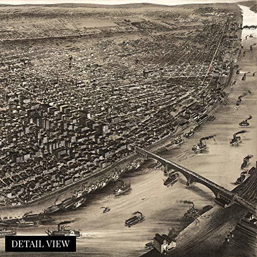
This detailed portrayal of St. Louis depicts the city in a time of significant prosperity, growth, and transformation. By the end of the nineteenth century St. Louis had become the fourth largest American city and was thriving economically. The city was experiencing massive cultural evolution and becoming one of the jewels of the American midwest. It had the nation’s tallest skyscraper constructed in 1891 and was as culturally significant as any American city at the time. Extensive railroad lines and St fueled the rapid westward expansion, and St. Louis was one of the largest hubs allowing travel throughout the nation to go through the city.
Produced in the distinctive Birds Eye perspective by noted lithographer Charles Juehne, a popular illustration style in the latter portions of the nineteenth century, this stunning map immediately transports the viewer back in time and creates a unique link between past and present. Birds Eye perspectives were produced as marketing materials for prominent cities and would detail notable businesses, civil buildings, and other enticing features.
St. Louis had seen industrialization like no other city following the Civil War's conclusion in 1865, and vast fortunes were being made in manufacturing plants. This created a population explosion as eager Southern Americans flocked to the city for employment. Additionally, its location at the Ohio, Mississippi, and Missouri rivers' confluence made it uniquely suited for inter-regional trade. Publish during a significant period in St. Louis’ evolution; this is truly an authentic piece of Americana cartographical history.
Our museum quality giclee print comes printed with archival ink on premium heavyweight matte paper. Shipped in a sturdy cardboard tube your print will arrive ready to be framed. This eye-catching vintage map reproduction print makes the perfect gift for anyone that loves history and imagery.